
This section takes a deeper look at the processes that guides streams and rivers. Rivers are dynamic systems. While we may represent them on maps as being fixed in space, the form, flows, and water quality of rivers change greatly with the seasons and over the years. A mountain stream may be furious whitewater in June, tranquil in August, and frozen in January. A prairie stream may be a muddy rush after a rainstorm, but dry a month later. Understanding the complex, dynamic nature of rivers and streams allows us to make responsible decisions about how we interact with them.
Hydrology and Flooding
Montana is a headwater state: most of the water in our rivers is generated by precipitation in Montana, along with inflows from Wyoming and Canada. Mountain streams are driven by mountain snowmelt, large prairie and valley rivers are driven both by mountain snowmelt and lower elevation rain and snow events, and small prairie streams tend to be ephemeral, only flowing during nearby snowmelt and after rainfall. Stream flows in Montana rivers tend to undergo huge swings throughout the year, as shown by these hydrographs for the Boulder River (a medium-sized mountain river in Sweet Grass County) and the large Yellowstone River in eastern Montana:

High flows associated with mountain snowmelt tend to occur in May and June.

Increased flows from prairie snowmelt can occur earlier, and high flows in prairie streams can occur throughout the summer in response to intense rain events.
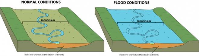
These floodwaters spread across the floodplain, the section of adjacent low-lying land. The floodplain slows and stores floodwaters, reducing the damaging energy of flows in the channel. Floodplains are formed by deposition of sediment over long periods of time and play important roles in maintaining healthy plant and animal communities.
Stream Patterns
Different hydrologic and geologic settings produce a wide variety of stream shapes. Streams can be more or less sinuous. They can primarily be a single channel, have islands and side channels, or be a complex network of braided channels.

Source: NPS
Channel Features
Let’s go over some features and characteristics of channels:
- Thalweg: the line tracing the deepest part of the channel
- Meanders: most streams follow a series of bends or loops that are caused by erosion and deposition of sediments
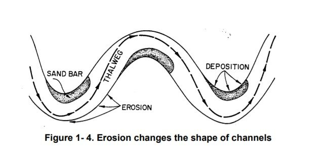
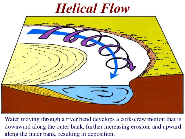
Sediments are eroded from the outside (convex) side of the bend and deposited on the inside (concave) side. Why is this? Like the way your car’s differential works on a curve allowing the outside tires to spin faster than the inside tires, water going around a bend is faster on the outside than on the inside. Sediment is therefore eroded from the outside of the bend. The water surface is also higher on the outside of a bend (think about spinning a water bucket on the end of a rope – how does the water surface respond?) This causes helical flow, where water spins in a corkscrew bringing sediment to be deposited on the inside of a bend.
The accumulation of sediment on the inside of a bend is known as a point bar and an eroding outer bend is known as a cut bank.
Pools and Riffles:

Depth is not constant in streams. Most streams show a regular pattern of pools (deep and flow moving) and riffles (shallow and fast moving). This riffle-pool pattern plays an important role in the life cycles of many fish and aquatic macroinvertebrates.
Pools are located the outside of bends, where erosional forces deepen the channel. Riffles are located between bends. But if riffles have fast moving flow, why do riffles not erode and fill up pools? To answer this, consider that erosion ability (shear stress) is proportional to pressure (I.e., depth) and velocity (I.e., slope). At low flows there is a huge difference in slope between pools and riffles, so fine sediment is eroded from the riffles and settles in the pools. But at high flows the differences in slope became evened out. The greater depth in pools pushes large sediment (gravel, cobbles, rocks) out of the pools where it settles on riffles. Next time you wade in a stream, feel the difference in sediment size between pools and riffles. Having a complex channel with a variety of flow conditions and sediment sizes is important for fish and other aquatic life.
Sediment Transport and Dynamic Equilibrium
Streams and rivers transport sediment across the landscape by eroding in one location and depositing in another. A common model for understanding sediment transport in streams in Lane’s Balance:

In mathematical terms, this is a proportional relationship between sediment load in the stream (Qs) and stream flow (Qw), where D is sediment size and S is the slope of the stream:
Qs D ∝ Qw S
In other words, changes to one variable of the balance such as increased flows from snowmelt or decreased sediment load due to bank armor provokes changes to the other variables to maintain the balance. Increased flows have the capacity to carry a larger volume of sediment (increasing Qs) as well as the competence to erode larger sediment particles (increasing D).
Let’s say we armor a section of the bank with rip-rap. This decreases the sediment load (Qs) since rip-rap by design prevents erosion. Rip-rap tends to increase the velocity of water by reducing friction with the banks, increasing the capacity and competence of the stream. When this fast and sediment-deficient stream encounters an unprotected bank, the resulting erosion will be worse than if the stream had no rip-rap. Artificially straightening and channelizing the stream has similar consequences, but because of an increase to the slope.
Dams have complex effects on sediment transport. On one hand, dams capture upstream sediment (reducing Qs) and causing increased erosion downstream to replace lost sediment. On the other hand, dams reduce peak flows (Qw) that may have previously eroded sediment downstream. The net effect depends on the situation. On the Colorado River in the Grand Canyon below Glen Canyon Dam, these changes combined with the very steep slope tilt the balance towards degradation where the very fast sediment-starved water erodes everything it comes across without leaving any sediment behind. However in the Colorado River along the Arizona-California border, dams and the mild slope tilts the balance towards aggradation and excessive sediment buildup due to insufficient flows to cause erosion.
Streams are in a state of dynamic equilibrium, where they respond quickly to changes to reach a new equilibrium state. Any human activities that alter the variables in Lane’s Balance will cause downstream impacts, such as increasing damaging erosion events. Furthermore, the integrity of native ecosystems relies on the natural dynamic character of flows, sediments, and temperatures. Alterations to these variables will inevitably cause damage to the native ecosystem and invite replacement by invasive species.